Back Turkanameer Afrikaans بحيرة توركانا Arabic Llagu Turkana AST Turkana gölü Azerbaijani Рудольф (күл) Bashkir Туркана (возера) Byelorussian Туркана (возера) BE-X-OLD Туркана (езеро) Bulgarian तुर्काना झील Bihari Lenn Turkana Breton
| Lake Turkana | |
|---|---|
| Jade Sea | |
 | |
 | |
| Location | Northwest Kenya and stick with Southwest Ethiopia |
| Coordinates | 3°35′N 36°7′E / 3.583°N 36.117°E |
| Lake type | Saline, monomictic, alkaline, endorheic |
| Primary inflows | Omo River, Turkwel River, Kerio River |
| Primary outflows | Evaporation |
| Catchment area | 130,860 km2 (50,530 sq mi) |
| Basin countries | Ethiopia, Kenya, South Sudan |
| Max. length | 290 km (180 mi) |
| Max. width | 32 km (20 mi) |
| Surface area | 6,405 km2 (2,473 sq mi) |
| Average depth | 30.2 m (99 ft) |
| Max. depth | 109 m (358 ft) |
| Water volume | 193 km3 (46 cu mi) |
| Salinity | 0.244%[1] |
| Surface elevation | 360.4 m (1,182 ft) |
| Islands | North Island, Central Island, South Island (volcanic) |
| Settlements | El Molo, Loyangalani, Kalokol, Eliye Springs, Ileret, Fort Banya. |
| References | |
| Official name | Lake Turkana National Parks |
| Criteria | Natural: viii, x |
| Reference | 801 |
| Inscription | 1997 (21st Session) |
| Extensions | 2001 |
 | |
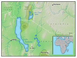
Lake Turkana (/tɜːrˈkɑːnə, -ˈkæn-/) is a saline lake in the Kenyan Rift Valley, in northern Kenya, with its far northern end crossing into Ethiopia.[2] It is the world's largest permanent desert lake and the world's largest alkaline lake. By volume it is the world's fourth-largest salt lake[3] after the Caspian Sea, Issyk-Kul, and Lake Van (passing the shrinking South Aral Sea), and among all lakes it ranks 24th.
Lake Turkana is now threatened by the construction of the Gilgel Gibe III Dam in Ethiopia due to the damming of the Omo river which supplies most of the lake's water.[4]
Although the lake commonly has been—and to some degree still is—used for drinking water, its salinity (slightly brackish) and very high levels of fluoride (much higher than in fluoridated water) generally make it unsuitable, and it has also been a source of diseases spread by contaminated water. Increasingly, communities on the lake's shores rely on underground springs for drinking water.[5] The same characteristics that make it unsuitable for drinking limit its use in irrigation.[6] The climate is hot and very dry.
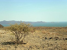
The rocks of the surrounding area are predominantly volcanic. Central Island is an active volcano, emitting vapour. Outcrops and rocky shores are found on the east and south shores of the lake, while dunes, spits and flats are on the west and north, at a lower elevation.
On-shore and off-shore winds can be extremely strong, as the lake warms and cools more slowly than the land. Sudden, violent storms are frequent. Three rivers (the Omo, Turkwel and Kerio) flow into the lake, but lacking outflow, its only water loss is by evaporation. Lake volume and dimensions are variable. For example, its level fell by 10 m (33 ft) between 1975 and 1993.[7] Despite the lack of outflow, in ecology it is often regarded as a part of—or at least associated with—the Nile basin because of its prehistoric connection to this system and the similarities in their aquatic faunas.[6]
Due to temperature (its surface water typically is 27–31 °C [81–88 °F] and the mean air temperature of the region generally is similar or slightly higher), aridity and geographic inaccessibility, the lake retains its wild character.[6] Nile crocodiles are found in great abundance on the flats. The rocky shores are home to scorpions and carpet vipers. The lake is rich in fish and fishing is very important to the local economy, but this is threatened by falling water levels and overfishing.[4]
Lake Turkana National Parks are now listed as a UNESCO World Heritage Site. Sibiloi National Park lies on the lake's eastern shore, while Central Island National Park and South Island National Park lie in the lake. Both are known for their Nile crocodiles.
An abundance of hominid fossils have been discovered in the area surrounding Lake Turkana.[4]
The area still sees few visitors, being two days' drive from Nairobi. The lake is also an imaginary boundary of the Rendille and Borana and Oromo to the Turkana land. The area is primarily clay-based and is more alkaline than seawater.
- ^ Hydrological Impacts of Ethiopia’s Omo Basin On Kenya’s Lake Turkana Water Levels & Fisheries (2010), page 2-65
- ^ The boundary between Ethiopia and Kenya has been a contentious rational distinction. A brief consideration of the topic can be found in the State Department document, Ethiopia – Kenya Boundary Archived 18 March 2009 at the Wayback Machine
- ^ "Lake Turkana in Kenya - The Jade Sea". www.kenyasafari.com. Retrieved 25 May 2020.
- ^ a b c Moran, B. (23 May 2017). "A way of life under threat in Kenya as Lake Turkana shrinks". The New Humanitarian. Retrieved 8 November 2019.
- ^ Serem, B. (29 November 2012). "For villages in Turkana, Kenya, a new initiative that brings clean water to the community is life-changing". UNICEF. Archived from the original on 8 November 2019. Retrieved 8 November 2019.
- ^ a b c Johnson, T.C.; J.O. Malala (2009). "Lake Turkana and its connection to the Nile". In H.J. Dumont (ed.). The Nile. Monographiae Biologicae. Vol. 89. Springer Science + Business Media B.V. pp. 287–306. ISBN 978-1-4020-9725-6.
- ^ Historic lake levels are graphed in the World Lakes Database Archived 18 January 2006 at the Wayback Machine.
© MMXXIII Rich X Search. We shall prevail. All rights reserved. Rich X Search

